NC Newsletter
Sign-up
Be the first to get the latest guided
hikes and NC Trail news
CLICK HERE
Read the daily
NC Visitor Guide BLOG for NC Park events,
cabin specials and what to do in the NC mountains.
advertise your NC rental or business to NC visitors CLICK HERE
Thousands ofNC waterfalls can be found
throughout the Western Carolina mountains and most are easily accessible by
well-maintained footpaths. There are over 250 in Transylvania County alone
(known as the land of the waterfalls)with many located within the Pisgah National Forest, Dupont State Forest and Gorges
State Park. Virtually every North Carolina river begins or ends with a waterfall, some extending as high as 400+ feet. Any visit to the
NC mountains must include at least one visit to
the spectacular North Carolina waterfalls they have created.
Land of the Waterfalls Camera Club
The Land of Waterfalls Camera Club was organized in the
fall of 2006 for photographers in the Brevard and
Transylvania County area of Western North Carolina. The
club’s orientation is towards the craft of making
high-quality images. The club is open to all
photographers, digital or film, beginner or advanced,
interested in learning, growing and improving their
photography.
Your tour starts with pickup from
your Asheville hotel by air-conditioned
van for the drive along the Blue Ridge
Parkway, during which you'll listen to
interesting facts about the area from
your guide. On an easy to moderate hike,
visit three waterfalls that you'll reach
via two protected forests. In total, you
will cover about 3.5 miles in
approximately 2 hours. There will be
time to take a break by the falls and
enjoy a provided snack and cool
beverage.
This 70 foot waterfall is accessed from the Crabtree Falls Camping area via a 2.5-mile moderate loop hiking trail of
moderate to strenuous difficulty. The hike takes you
through a pristine forest to beautiful views of the
waterfall as close as you care to get. The loop trail follows beautiful Crabtree Creek after you pass the waterfall.
Directions:
One the Blue Ridge Parkway at Milepost 339.5
west of Little Switzerland.
Cascading
about 250 feet
Cullasaja Falls is a fitting climax to
the trio including Bridal Falls and Dry Falls
as you proceed west form Highlands. The
falls can be viewed from the highway but
there is no designated parking area. There
is an extended wide spot pull off for 3 or
4 cars. The trail to the base of the falls
is steep and rocky and recommended for the
experienced only.
Directions: On US-64
between Highlands and Franklin, about 8
miles from Highlands on a narrow curving
2-lane road.
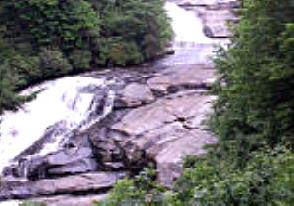
High Falls is the largest of the Dupont falls
with a
150-foot cascade down an inclined plane of granite.
Triple Falls offers
three
cascades with a total 120-foot drop. Hooker
Falls includes a popular spot for wading and swimming in Casade Lake at the foot of the 11-foot waterfall. A three-mile roundtrip hike (mostly level with a couple of climbs)
on a pet-friendly trail takes you to
all three beautiful waterfalls.
Directions: From Brevard turn east on U.S. 64 for 3.7 miles to the Texaco station in Penrose. Turn right on Crab Creek Rd and continue 4.3 miles
to right on DuPont Road for 3.1 miles. The Hooker Falls parking lot
is on the right just before the Little River bridge. One mile past this parking area is the larger High Falls parking area with restrooms and water.
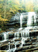
Hickory
Nut Falls is in Chimney Rock Park, now a state owned park, in the
western part of Rutherford County in between Lake Lure and Bat Cave.
The falls are a series of drops for better than 900
feet. The main falls swoops over a granite ledge and
drops some 400 feet to the pool below.
Directions:
From Hendersonville, take US-64 to the intersection of
US74-A, turn right to the park entrance (well signed)
which will be on your right a few miles down along the
Broad River.
At the
head of the Linville Gorge is the famous Linville Falls which is
actually two falls: Upper Falls (50 feet) and Lower Falls (60 feet). Two
main hiking trails lead to beautiful views of the
Linville Falls. Both begin at the Linville Falls Visitor
Center, which is operated by the National Park Service.
The An information station at the
parking lot has brochures about the falls you should read before you start
the
climb. The trails range in difficulty from moderate to strenuous.
Directions: Off the Blue
Ridge Parkway between at milepost 316.3. Access to the Falls can
also be obtained from the Kistler Memorial Highway, 105.
At the Linville Falls Community, take NC 183 for 1/2 a
mile. Turn right on NC 105. Go 1/10 of a mile to the
parking lot on the left. The Linville Falls trail is .5
miles long and connects to the Park Service trail
system.
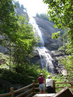
One of the most popular falls in Western North
Carolina, Looking Glass Falls are 60 feet tall and
easily viewed. The name "Looking Glass" comes from
Looking Glass Rock, where water freezes on its sides in
the winter and then glistens in the sunlight like a
mirror or looking glass. Steps lead down to the falls,
and photo spots are also located along the railing near
the road.
You may walk on the rocks or wade in the stream
below the falls, and even swim underneath the
falling water.
Directions: Located directly on U.S. 276.
From Brevard take U.S. 276 north about 5 miles past the
entrance to Pisgah National Forest. The falls are on the
right.
Mingo Falls on the Cherokee Indian Reservation is an
impressive 120 foot drop, one of the tallest and
most spectacular in the southern Appalachians.
The waterfall is accessed by Pigeon Creek Trail, a short
.4 mile hike which is moderately difficult.
Directions: From downtown Cherokee take U.S.
441 to Acquoni Road, which runs beside the Oconaluftee
River. At the Saunooke Village shopping center
turn right onto Big Cove Road for about 5 miles to the
signs for Mingo Falls Campground. The waterfall is
adjacent to the campground.
Pearson's Falls are located on private property and a
small fee is charged for access.
The falls have a total descent of about 100 feet. Access
to a wildflower garden with adjacent picnic tables is
included in the admission fee. The remarkable botanical
diversity and the beautiful waterfalls in this peaceful
glen have attracted nature-lovers, botanists, artists
and picnickers for many generations. Visitors today can
enjoy the falls and native wildflower garden, as well as
the over 200 ferns, flowering plants, algae and mosses
of Pearson's Falls by hiking the quarter-mile Glen
Trail. The trail is well-maintained and an easy to
moderate hike suitable for for all ages.
Directions:Take US-176 south from
Saluda or north from Tryon to Pearson Falls Road (about
4 miles). The parking area is 3.5 miles away along a
well-maintained gravel road.
(Upper) Whitewater
Falls, located in the Nantahala National Forest near Cashiers, NC, drops
over 411 feet and is the highest falls east of the Rocky Mountains. (Lower
Whitewater Falls, located just across the border in South Carolina, drops
another 400 feet) The rugged terrain around these two waterfalls remains
wild and undeveloped. A paved, accessible 100 yard path leads from the
parking lot to the upper overlook with an excellent
view of Whitewater Falls. A lower overlook is located
at the bottom of 154 wooden steps. Directions: From Brevard NC take US 64
west for about 18 miles and turn left on Whitewater
Road. Continue 8 miles to the park entrance on the
left.
Other NC Waterfalls
Alarka Falls - From Bryson City take 74 West to
exit 64 (Alarka Road) continue about 10 miles to end.
Over 200 ' falls in secluded area
Glen Falls From Highlands, travel 3
miles south on NC 106. Turn left on the U.S.
Forest Service Rd. with the "Glen Falls" marker.
The 1-mile trail to the falls is steep and
rough. Glen Falls actually is a series of three
large falls, each dropping approximately 60 feet
Silver Run Falls From Cashiers take NC 107,
4.1 miles. Park in the pull-off on the left. There is a short, easy trail to the base of the falls.
Upper Creek Falls
Take NC 181 North 13.5 miles from Morganton. The parking area is on the right about 6 miles north of the Pisgah National Forest boundary.
NC Waterfall Information
Websites
North Carolina Waterfalls
This site is written and
maintain by a waterfall enthusiast who works and
lives in Asheville. There are 100s of
photographs, directions and descriptions and the
site is a great resource for planning your
waterfall visits.
NC Waterfalls Map An
interactive Google map with links back to
details and descriptions for the individual
waterfalls.
Transylvania
County Waterfalls
Conestee Falls - Just south (about 6 miles) of Brevard on US-276, the twin
falls (on your right) are about 110 feet high and are easily reached by
a staired walkway. In fact, the walkway, up to a vantage point from
which you can view the falls, is very nice, level, brick-paved, and
ck-paved, and wheel-chair accessible. Connestee Falls are on private
land and are accessible free of charge through the generosity of the
owner. 828-885-2610.
Rainbow Falls is for waterfall addicts. It is on private land and only accessible by a
poorly marked, narrow, very rocky trail. The falls are some 200 feet
high and, especially after the spring rains, are really worth the
effort. The mist created by the water splashing furiously against all
the rocks creates a permanent rainbow - hence the name. Take US-64
west from Brevard to NC-281. Turn left (south), another 2 miles and park
on the side of the highway just before you cross the bridge.
Horsepasture Falls. Named after the river, this is one of a series of magnificent
waterfalls on the Horsepasture River. From Cashiers follow US-64 east 10
miles to Sapphire. Turn right on the 'Whitewater' Road and then south
about 3 miles to the Horsepasture River. Drift Falls (Bust Your Butt Falls) . From
Cashiers follow US-64 10 miles east to Sapphire. Turn right on the
'Whitewater' Road and then south about 3 miles to the Horsepasture
River. Whitewater Falls. This set of two waterfalls
is located 10 miles south of Cashiers NC
NC-28 in the Nantahala National Forest
of North Carolina. Whitewater Fallsis really two waterfalls, the
Upper (411 feet) and the Lower Falls (285 feet). This is the highest set
of falls east of the Rocky Mountains having a total drop of almost 700
feet. There is a well maintained trail from the paved parking lot
(complete with rest rooms) and it is an easy walk to the many vantage
points. Cove Creek Falls. From its intersection with US-64 and
NC-280 just east of Brevard, follow US-276 north about 5 miles to the
Fish Hatchery (on your left). Turn left (this is FR-475) and
proceed to Cove Creek Campground. The falls is about a mile from the
parking lot over a fairly decent trail.Slick Rock Falls. From
its intersection with US-64 and NC-280 just east of Brevard, follow
US-276 north about 5 miles to the Fish Hatchery (on your left). Turn
left (this is FR-475) and continue another 1.5 miles to 475-B. Turn
right, go another mile and you're at Slick Rock Falls. Just up the road
at Cove Creek Campground is a short, 1 mile trail to Cove Creek Falls.
And a little further on FR-475 is
Daniel Ridge Falls, both of
which you will want to see.High Falls(Pisgah National Forest) On
the Mills River near Pink Beds, 135 feet of drop are probably enough of
an inducement to get you to make the 2.5 mile, rugged hike (the trail is
very rough and steep). No formal parking area has been constructed;
you'll have to find a good spot along the road. Take US-276 north
from Brevard into Pisgah National Forest to Yellow Gap Road. There is a
sign. Looking Glass Falls (Pisgah National Forest) Looking Glass
Falls is actually a 30-foot wide cascade over a sloped 60-foot surface
of polished granite (said to be the largest single granite rock in the
southern Appalachian Mountains). Looking Glass Falls is on US-276 22
miles south of Waynesville and about 5.5 miles north of SC-280 in
Brevard. The parking area is well marked on east side of the highway.
It's just a short walk to the falls. You will surely want to continue a
little further after looking at Looking Glass Falls: there is Moore Cove Falls and then
Sliding Rock Falls. A little further and
you will be on the Blue Ridge Parkway
Great Smoky
Mountains
National Park Waterfalls
Indian Creek Falls. From
Bryson City, follow Deep Creek Rd. north about 3 miles to the Deep Creek
Campground in the Great Smoky Mountains National Park. Height of falls
is 60 ft. The one-mile hike to the falls is classified as
"easy". Juney Whank Falls. Falls is one-quarter mile
downstream on Indian Creek.
Tom Branch Falls. From Bryson City,
follow Deep Creek Rd. north about 3 miles to the Deep Creek Campground
in the Great Smoky Mountains National Park. Tom's Branch Falls is
an easy quarter-mile walk from the Deep Creek Campground.
Stone Mountain
State Park Waterfalls
Stone Mountain Falls. Accessed
by a 1.2 mile trail, this mighty 200 foot drop waterfall is one of the
most magnificent of the Carolina hydro-spectaculars. The
specially-constructed wood staircase, which allows safe access to the
base of the falls, shows the concern of the NC Parks Division for your
safety. And it certainly makes access so much easier than climbing down
a steep, rocky (and probably slippery) trail - and back up again. But
there are a lot of stairs to climb on your way up, so - be prepared. Two
other falls are also on Big Sandy Creek: Middle Falls and Lower
Falls. They are also accessible from the
Stone Mountain Falls
Trail*. They aren't as dramatic as Stone Mountain Falls but, if you love
waterfalls, you will certainly enjoy them.
Soco Falls
From Cherokee follow US-19 north about 6 miles to Soco Falls (located on slopes of Soco Bald).
Cashiers area
WaterFalls
Horsepasture River Falls. Named after the river, this is one of a series of magnificent waterfalls on the Horsepasture River. From Cashiers follow US-64 east 10 miles to Sapphire. Turn right on the 'Whitewater' Road and then south about 3 miles to the Horsepasture
River. Toxaway Falls. From Cashiers, take US-64 east. The highway passes over the falls (about 16 miles east of Cashiers).
Drift Falls. From Cashiers follow US-64 10 miles east to Sapphire. Turn right on the 'Whitewater' Road and then south about 3 miles to the Horsepasture
River. Kiesee Falls. Between Cashiers and Brevard, from Cashiers, travel 16 miles east on US-64, to Glouchester Road. Kiesee Falls is on Kiesee Creek in Balsam Grove. Courthouse Falls. From Cashiers, follow US-64 east 16 miles to NC-215. Turn right (north) and continue to Balsam Grove and Courthouse Creek. In the rugged wilds of the Beech Gap area on Courthouse Creek in the Beech Gap area of the Pisgah National Forest is this 45 foot high waterfall plunging into a secluded pool just like in a story book. A short, 0.3 mile trail of medium difficulty leads from the highway. Not wheelchair accessible.
 NC
Waterfalls in the Mountains
NC
Waterfalls in the Mountains 
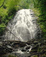 This 70 foot waterfall is accessed from the Crabtree Falls Camping area via a 2.5-mile moderate loop hiking trail of
moderate to strenuous difficulty. The hike takes you
through a pristine forest to beautiful views of the
waterfall as close as you care to get. The loop trail follows beautiful Crabtree Creek after you pass the waterfall.
This 70 foot waterfall is accessed from the Crabtree Falls Camping area via a 2.5-mile moderate loop hiking trail of
moderate to strenuous difficulty. The hike takes you
through a pristine forest to beautiful views of the
waterfall as close as you care to get. The loop trail follows beautiful Crabtree Creek after you pass the waterfall.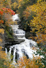 Cascading
about 250 feet
Cullasaja Falls is a fitting climax to
the trio including
Cascading
about 250 feet
Cullasaja Falls is a fitting climax to
the trio including
 Hickory
Nut Falls is in Chimney Rock Park, now a state owned park, in the
western part of Rutherford County i
Hickory
Nut Falls is in Chimney Rock Park, now a state owned park, in the
western part of Rutherford County i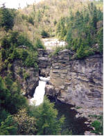 At the
head of the Linville Gorge is the famous Linville Falls which is
actually two falls: Upper Falls (50 feet) and Lower Falls (60 feet). Two
main hiking trails lead to beautiful views of the
Linville Falls. Both begin at the Linville Falls Visitor
Center, which is operated by the National Park Service.
The An information station at the
parking lot has brochures about the falls you should read before you start
the
climb. The trails range in difficulty from moderate to strenuous.
At the
head of the Linville Gorge is the famous Linville Falls which is
actually two falls: Upper Falls (50 feet) and Lower Falls (60 feet). Two
main hiking trails lead to beautiful views of the
Linville Falls. Both begin at the Linville Falls Visitor
Center, which is operated by the National Park Service.
The An information station at the
parking lot has brochures about the falls you should read before you start
the
climb. The trails range in difficulty from moderate to strenuous.
 Pearson's Falls are located on private property and a
small fee is charged for access.
The falls have a total descent of about 100 feet. Access
to a wildflower garden with adjacent picnic tables is
included in the admission fee. The remarkable botanical
diversity and the beautiful waterfalls in this peaceful
glen have attracted nature-lovers, botanists, artists
and picnickers for many generations. Visitors today can
enjoy the falls and native wildflower garden, as well as
the over 200 ferns, flowering plants, algae and mosses
of Pearson's Falls by hiking the quarter-mile Glen
Trail. The trail is well-maintained and an easy to
moderate hike suitable for for all ages.
Pearson's Falls are located on private property and a
small fee is charged for access.
The falls have a total descent of about 100 feet. Access
to a wildflower garden with adjacent picnic tables is
included in the admission fee. The remarkable botanical
diversity and the beautiful waterfalls in this peaceful
glen have attracted nature-lovers, botanists, artists
and picnickers for many generations. Visitors today can
enjoy the falls and native wildflower garden, as well as
the over 200 ferns, flowering plants, algae and mosses
of Pearson's Falls by hiking the quarter-mile Glen
Trail. The trail is well-maintained and an easy to
moderate hike suitable for for all ages.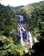 (Upper) Whitewater
Falls, located in the Nantahala National Forest near Cashiers, NC, drops
over 411 feet and is the highest falls east of the Rocky Mountains. (Lower
Whitewater Falls, located just across the border in South Carolina, drops
another 400 feet) The rugged terrain around these two waterfalls remains
wild and undeveloped. A paved, accessible 100 yard path leads from the
parking lot to the upper overlook with an excellent
view of Whitewater Falls. A lower overlook is located
at the bottom of 154 wooden steps.
(Upper) Whitewater
Falls, located in the Nantahala National Forest near Cashiers, NC, drops
over 411 feet and is the highest falls east of the Rocky Mountains. (Lower
Whitewater Falls, located just across the border in South Carolina, drops
another 400 feet) The rugged terrain around these two waterfalls remains
wild and undeveloped. A paved, accessible 100 yard path leads from the
parking lot to the upper overlook with an excellent
view of Whitewater Falls. A lower overlook is located
at the bottom of 154 wooden steps. 