NC Newsletter
Sign-up
Be the first to get the latest guided
hikes and NC Trail news
CLICK HERE |
|
|
|
Read the daily
NC Visitor Guide
BLOG
hiking events, Mountain
cabin specials and what to do in the NC mountains. |
|
advertise your NC cabin with onsite trails on
this site
CLICK HERE |
|
|
|
|
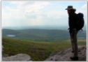
The NC Mountains offer
Hikers of all ages and abilities some of the best hiking
trails and most
enjoyable settings in the country. Within the
beautiful
mountains of North Carolina,
1000's of
Trails
are easily accessible for
everything form a short Blue
Ridge Parkway hike to challenging, overnight
adventures. |
|
| |
| |
| |
|
Carolina Mountain Club The Carolina Mountain Club,
now over 80 years old and the oldest Hiking and Trail Maintaining Club
in Western NC fosters the enjoyment of the mountains of Western North
Carolina and adjoining regions. Their activities include: 175 hikes per
year, maintaining 400 miles of trail, an active program to build new
trails, promoting the conservation of the trails and natural scenery in
the area, educating members on hiking, trail building and maintenance
skills, working with the U.S. Forest Service, the National Park Service,
and the State of North Carolina to achieve these goals. |
|
|
|
|
|
|
|
|
The
Chargers & Rechargers Hiking Club. an informal loose-knit group of
hiking enthusiasts in the western and northwestern mountains of North Carolina.
Visitors are welcome. Most of the membership lives in the area stretching from Burnsville and Spruce
Pine up to Boone. The Club schedules hikes year round in the surrounding areas
in locales such as Linville Gorge, the Blue Ridge Parkway, the Appalachian
Trail, Roan Mountain (Tennessee), and the Virginia Creeper Trail (Virginia).
Most hikes are held on Saturday and Wednesday and last four to five hours. Hikes
range in difficulty from easy to strenuous. |
|
|
|
|
|
|
|
North
Carolina Trails Program The State Trails Program
is a section of the Division of Parks and Recreation.
The program originated in 1973 with the North Carolina
Trails System Act and is dedicated to helping citizens,
organizations and agencies plan, develop and manage all
types of trails ranging from greenways and trails for
hiking, biking and horseback riding to river trails and
off-highway vehicle trails. |
|
|
|
Hiking Links: |
|
|
| |
|
NC
Hiking BLOGS |
|
|
| |
|
Cradle of Forestry Virtual Hike
Take an online tour of the Biltmore Campus Trail. You
may also walk the Trail with your real time feet and
visit the Educational Center and gift shop at the Cradle
of Forestry, just outside Brevard NC. You'll se the
original campus which was the forestry training center
and beginnings of the US Division of Forestry. |
|
|
Hiking Publications |
|
|
| |
| |
|
|
NC Guided Hikes and Trail News: |
Date:
NC City:
Event:
|
|
|
|
Popular NC Park Trails and Favorite
Family Hikes |
|
|
|
Grandfather Mountain |
More than 12 miles of regularly maintained
trails ranging in difficulty from easy nature
walks to strenuous backcountry challenges
For
experienced hikers, the two-mile Grandfather Trail makes its way through
patches of spruce and fir and across rock outcrops with the help of
ladders and cables. For hikers seeking a less strenuous adventure, try
the Black Rock Trail. Starting at the Grandfather Mountain attraction,
the trail offers panoramic views of several surrounding mountain peaks,
including MacRae and Attic Window.
The Nature Walks offer a casual experience
on 3 of Grandfather's pristine trails to enjoy the
Mountain's incredible biodiversity up-close and
personal.
Can’t decide which of the 11
trails to hike first? Browse the free Backcountry Trail Guide offered
with your admission ticket or hiking permit. You can also spend some
time at the attraction, which includes a museum, gift shop and the Mile
High Swinging Bridge that spans an 80-foot gap at the top of Linville
Peak |
|
|
|
Chimney Rock
State Park
|
The Hickory Nut Gorge area is known for its flora and fauna – as
well as the famous scenery. You'll get to experience both on any of the
five hiking trails including one that leads to
Hickory Nut Falls, which plunges 404 feet down a sheer
rock face. It and other parts of the Park were used as
background in the 1991 film “The Last of the Mohicans” starring Daniel
Day-Lewis.
One of the unique aspects of Chimney Rock is the
26-story elevator that operates inside the towering pillar of igneous
rock that gives the park its name. Once at the top, you will be inspired
by the 360-degree
views from the summit. |
|
|
|
|
Mount Mitchell State
Park |
There are a few places in
the world that still stand apart from the ordinary Mt. Mitchell is
certainly one of them. Rising more than a
mile high, surrounded by the gentle mist of low-hanging clouds, Mount
Mitchell State Park is one of these extraordinary places.
Choose between
a short stroll or a more extensive hike into the woods. Either choice
will be rewarding as the beauty of the park is best seen from one of its
many trails. Hikers should wear appropriate clothing and carry proper
gear as the high altitude makes the climate of Mount Mitchell chilly,
even in summer.
A short trail beginning at the summit parking lot
leads to the observation platform. On a clear day, visitors can
see as far as 85 miles and enjoy spectacular views of the surrounding
mountains and the Pisgah National Forest. |
|
|
|
|
Linville Gorge- Pisgah National
Forest |
Linville Gorge was first
designated a wild area in 1951 by the Chief of
the Forest Service. With the signing of the
Wilderness Act of 1964, the area became one of
the original components of the National
Wilderness System. The original 7,575 acres
was increased to the present 12,002 acres by
the 1984 North Carolina Wilderness Act.
The Gorge,
which includes 39 miles of trails, is a rugged challenge
to even the most experienced hiker. As a true
Wilderness area, the Gorge offers
solitude and emersion in a natural setting without
vehicles or amenities. The Wilson Creek area, Lost Cove,
and Curtis Creek are excellent for hiking and
backpacking. Information on these and other areas is
available at the District Ranger's Office.
The Linville Gorge Area offers some of the most
strenuous
mountain biking
trails anywhere in the east, with a
variety of routes ranging from 8.2 miles to 49 miles and
some mighty incredible scenery along the way. |
|
|
|
Roan Mountain – Rhododendron Gardens
National Recreation Trail |
Naturalists have journeyed to the 6,327-feet high Roan Mountain
for more than two centuries to study its diversity of plant life. The
Roan Mountain – Rhododendron National Recreation Trail features an easy,
one-mile hike through the popular rhododendron gardens, which explode in
color between mid-June and early July each year, drawing visitors from
around the world. To time your visit with the bloom, visit
roanmountain.com for updates.
The trail is divided into three
loops, each suitable for hikers of all ages. The first loop is a paved,
handicap-accessible interpretive trail with 16 stations keyed to
information in a free brochure explaining the exotic and rare plants
found on the mountain. |
|
|
|
|
Joyce Kilmer National Recreation Trail |
More than just a hike, this easy two-mile trek is a journey back to a
time when vast forests were untouched by human hands. Located in the
largest tract of virgin hardwoods east of the Mississippi, it inspired
soldier-poet Joyce Kilmer to pen “Trees.”
The trail features two
loops - the 1.25-mile lower loop and the .75-mile upper loop, which
showcases the largest trees in the forest. Both loops converge at the
Joyce Kilmer Memorial. |
|
|
|
|
Whiteside Mountain National Recreation Trail |
This gravel and soil trail features one of the
more dramatic settings in the North Carolina mountains. But its
steepness makes it better for experienced hikers.
Sheer white
cliffs rise 400 to 750 feet along the sides of 4,930-feet tall Whiteside
Mountain, providing a clear landmark for miles around. A two-mile
moderate loop trail to the summit features inspiring views from the
ridge tops. NEAREST CITY: Highlands NC |
|
|
|
|
Stone Mountain State Park |
The Park features more than 16
miles of hiking trails that wind through forests of oak, hickory and
pine before going over and around a massive granite dome that rises 600
feet above the valley floor.
In addition to hiking, you can
climb certain cliffs. Specific rules apply so check with
the ranger station before climbing. If you’re less
adventurous, spend time at the historical exhibits,
which include a log cabin and blacksmith shop, complete
with original furnishings and tools. Bring your fishing
rod, too. Twenty miles of Wild Trout Waters are
available at the park. |
|
|
|
|
|
|
North Carolina
Mountains-to-Sea Trail: |
Mountains-to-Sea Trail
The
Mountains-to-Sea Trail connects Clingman's Dome in the Great Smoky Mountains
National Park to Jockey's Ridge State Park on
the Outer Banks with nearly 1200 miles of footpaths
and temporary connectors. Currently about 700 miles
of footpaths are complete with work crews,
mostly volunteers, continuing construction.
The connectors make it possible to hike the
entire 1200 miles.
The route passes through 37 counties containing
about 40 percent of the state's population.
The trail is used by people out for an
afternoon stroll as well as those planning to
hike the trail from one end of the state to
the other.
In 2021 the Trail celebrates its 44th anniversary.
Join the celebration with the
44 Mile Challenge.
Hike 44 miles anywhere on the MST during September for
a chance to win one of 6 great prize packs from REI, |
|
|
|
The Appalachian Trail |
The Appalachian Trail
travels along 300 miles of beautiful
North Carolina mountains. Well known by the
locals as offering some of the most dramatic
views, here are some top hikes to get you back
in touch with mother nature.
Roan Mountain: Known
for it's expansive grassy balds and
flowering rhododendrons this area of the
AT offers gorgeous panoramic views. Visit
the Roan Mountain recreation area to find
restrooms, picnic tables and a paved
half-mile trail. Or park at Carver's Gap
for a longer seven-mile hike.
Clingman’s Dome: At
6,643 feet, this is the highest point
along the AT. From here you can hike on a
number of different trails that provide
stunning mountain vistas.
Read more here
Max Patch: Located
near Hot Springs, Max Patch offers 360
degree views atop 350 acres of open grassy
field. The AT passes right through the
middle and is a popular place especially
during leaf season.
Get Madison County Trail Access Points
here
The Appalachian
Trail in North Carolina.
The Trail crosses Western North Carolina from the Georgia
border to the Great Smoky Mountains National Park for
about 95.9 miles before turning
along the Tennessee border for another 287 miles until
it exits NC at the Virginia border. There are long
climbs in the Stecoah-Cheoah
Mountain area, and an
outstanding section in Nantahala with 4,000-foot gaps and
5,000-foot peaks. Cheoah Bald offers panoramic views of
western North Carolina. This part of the A.T.
provides a feeling of remoteness, and a sensation of being
in deep forests. The variety of forest growth and the
beauty of the flowering shrubs, along with the many
spectacular views, make this entire section of Trail
memorable.
 The
AT section from the Nantahala River to the Georgia border
features some the best-graded trail at high elevations and
there are lots of views from natural openings and
fire towers, some requiring short side trips. The
AT section from the Nantahala River to the Georgia border
features some the best-graded trail at high elevations and
there are lots of views from natural openings and
fire towers, some requiring short side trips.
Appalachian Trail follows segments of mountain ranges in
the Cherokee National Forest, ascending to the high
country of the North Carolina-Tennessee state line, and
the highest mountains along the Trail—several above six
thousand feet.
Here lie the Roan Highlands, noted for their rhododendron
gardens and the panoramic views of the open grassy “balds”
such as Hump Mountain. The A.T. continues southward along
the state line and through the Pisgah National Forest.
The Great Smoky Mountains National Park, with more than 70
miles of crestline Trail, features the highest elevations
of the entire footpath, well above six thousand feet.
Clingman's Dome is the highest point on the entire A.T.,
where the Trail reaches an elevation of 6,625 feet near
the summit. |
|
|
|
National Forest Trails |
National Forest trails are for hikers only, unless
signed and designated for bikes, horses, or ORV's. You should
assume that unsigned trails are hiking-only trails. Some trails provide educational experiences about nature or the area's history while others are "back-to-nature" adventures in pristine settings.
Over 1700
miles of national forest trails are open to discovery in North Carolina.
Some trails are easy and fun for families with small children; other
paths make great half-day hikes. Longer trails can lead to backpacking
adventures for a night or much longer. No permits are required for using
national forest trails (except for overnight stays in the Linville Gorge
Wilderness), though some areas have access fees. Wilderness trails are
the most primitive and should be used only by those with orienteering
skills. Check in with the District Ranger Station for the latest
information, maps and current regulations.
Bent Creek Experimental Forest Trails
- Asheville area. Hiking, biking and horseback
riding with a downloadable map available.
|
|
|
|
|
Hiking The Blue Ridge Parkway: |
|
The Trails are sorted by Milepost Marker with
links for details if available |
|
297 Price Lake Loop Trail (loop around Price Lake) 2.3 miles |
| 302.8
Rough Ridge 1/3 mile to wonderful views on
a boardwalk atop a rocky ridge. Tanawha Trail. |
| 304.4
Linn Cove Viaduct Visitor Center and
Tanawha Trail. |
| 305.2
Beacon Heights Trail,, one mile roundtrip
with panoramic views from a rock face
mountaintop. Tanawha Trail. |
|
|
| 308.2
Flat Rock
Trail (self-guiding loop) 0.63 Easy |
| 316.4
Linville Falls Trail: A trail through rare
virgin forest. Balcony views of the Falls and
the incredibly carved gorge. Labeled trail
aids. 0.8 mile Moderate |
|
316.4 Linville
Gorge Trail: View of lower Falls. 0.5
Strenuous. Read more about
Linville Gorge. |
| 316.4 Duggers Creek
Trail: Loop to view of Duggers Falls. 0.25
Easy |
| 316.5 Linville River Bridge Trail:
Leg stretcher to view of unusual bridge. 0.1
Easy |
| 320.8
Chestoa View Trail: 30-minute loop to
vista. 0.6 Easy |
| 339.5
Crabtree Falls Loop Trail: Loop to view of
Falls. 2.6 Strenuous |
| 344.1 Woods Mountain
Trail: USFS trail. 10.6 Moderate/Strenuous
|
| 350.4
Green Knob Lookout Tower. A lookout tower
with 360 degree views is a 1/2 mile hike.
Moderate/Strenuous |
| |
| 351.9 Deep Gap Trail:
USFS trail. 0.2 Easy |
| 355.0 Bald Knob Ridge
Trail: USFS Trail. Virgin red spruce and
Fraser fir. 2.8 Easy |
| 355.4
Mt. Mitchell State Park add
Mt. Craig |
| 359.8 Big Butt Trail:
Trail continues on USFS lands. Nice wildflower
displays just a short distance off the
Parkway. 6.2 Strenuous |
| 361.2 Glassmine
Falls: Just a few steps out of the parking
area to a view of Falls. 0.05 Moderate |
| 364.2
Craggy Pinnacle Trail: To panoramic view.
0.7 Moderate |
| 364.6 Craggy Gardens Trail:
First portion is self-guiding nature trail.
Beautiful displays of Catawba Rhododendron
bloom in June. 0.8 Moderate |
| 374.4
Rattlesnake Lodge Trail:
Woodland walk to
old homestead site, now just walls and
foundations. 0.5 Moderate |
| 382.0
Mountain-to-Sea Trail:
MTS Trail (from
Folk Art Center to Milepost 365 spring
wildflowers and views; parallels parkway; many
accesses). The Mountains to the Sea Trail is a
work in progress that will eventually cross
North Carolina from west to east. Many
sections, including most of the mountain
portions, are finished. 7.5 Moderate |
| 393.7 Shut-In Trail/MTS Trail:
Bent Creek-Walnut
Cove 3.1 Strenuous |
| 396.4 Shut-In
Trail/MTS Trail: Walnut Cove-Sleepy Gap. 1.7
Moderate |
| 397.3 Grassy Knob Trail: Steep
trail to USFS area. 0.9 Strenuous |
| 397.3 Shut-In Trail/MTS
Trail: Sleepy Gap-Chestnut
Cove. 0.7 Moderate |
| 398.3 Shut-In Trail/MTS
Trail: Chestnut Cove-Bent Creek Gap. 2.8
Strenuous |
| 400.3 Shut-In Trail/MTS Trail:
Bent Creek Gap-Beaver Dam Gap. 1.9 Moderate
|
| 401.7 Shut-In Trail/MTS Trail: Beaver Dam
Gap-Stoney Bald. 0.9 Moderate |
| 402.6 Shut-In Trail/MTS Trail: Stoney Bald-Big
Ridge. 1.2 Strenuous |
| 403.6 Shut-In
Trail/MTS Trail: Big Ridge-Mills River Valley.
1.1 Moderate/Strenuous |
| 404.5 Shut-In
Trail/MTS Trail: Mills River Valley-Elk
Pasture Gap. 1.2 Strenuous |
| |
| 405.5 Shut-In
Trail/MTS Trail: Elk Pasture Gap-Mt. Pisgah.
1.7 Strenuous |
| 407.6
Mt. Pisgah Trail:
360 degree summit view
from 5721 ft. mountain. 1.3 Moderate/Strenuous
|
| 407.6 Buck Springs Trail: Pisgah Lodge to
view. 1.06 Easy/Moderate |
| 408.5
Frying Pan Mountain Trail: To Big Bald.
Good wildflower area. Continue on FR 450 to
the fire tower for views. 2 Moderate/Strenuous
|
| 417.0 East Fork Trail: USFS trail access
to Shining Rock WildernessTrail System. 0.1
Easy/Moderate |
| 418.8
Graveyard Fields Loop Trail: Loop by a
stream with several waterfalls. 2.3 Moderate
|
| 419.4 John Rock Trail:
Leg stretcher to
view. 0.1 Easy |
| 420.2
Black Balsam Bald |
| 422.4
Devil's Courthouse Trail: Panoramic summit
view. 0.4 Moderate/Strenuous |
| 427.6 Bear
Pen Gap Trail: Access to Mountains-to-Sea
Trail. 0.2 Easy |
| 431.0 Richland Balsam
Trail: Self-guiding loop through spruce-fir
forest near the highest point on the Parkway.
1.5 Moderate |
| 433.8 Roy Taylor Overlook
Trail Paved trail to overlook. 0.1 Easy |
| 451.2
Waterrock Knob Trail: Summit view. 1.2
Moderate/Strenuous |
|
|
|
|
|
|
Hiking in the Great Smoky Mountains
National Park |
|
|
|
|
|
 NC
Hiking and Mountain Trails
NC
Hiking and Mountain Trails